

3月11日14時46分頃地震がありました。震源地は三陸沖(北緯38.0度、東経142.9度、牡鹿半島の東南東130km付近)で震源の深さは約24km、地震の規模(マグニチュード)は9.0と推定されます。
14:46 on March 11, 2011, a massive earthquake of magnitude 9.0 occurred around 130km east-southeast of Oshika Peninsula, off Sanriku. It was centered at 38.0°N, 142.9°E, with a depth of about 24km.
関連情報
■NDL東日本大震災アーカイブ(愛称:ひなぎく) パスコ提供コンテンツ一覧
※「ひなぎく」は、総務省および国立国会図書館が設立した、東日本大震災に関する音声・動画、写真、ウェブ情報等のデジタルデータや、関連する文献情報を一元的に検索・活用できるポータルサイトです。
パスコが国会図書館へ寄贈した東日本大震災関連の画像データは、「ひなぎく」上で公開されています。
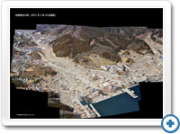
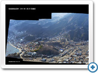
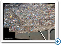
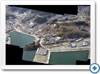
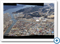
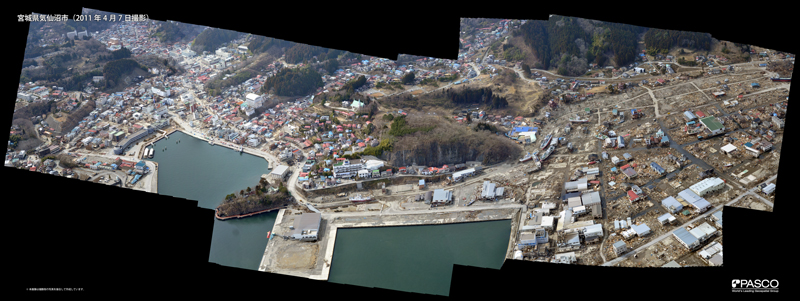
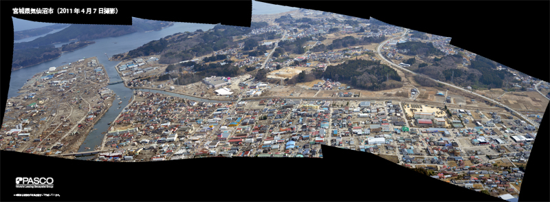
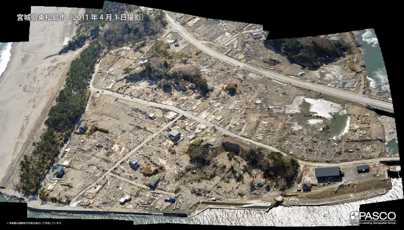
22.高解像度パノラマ航空写真
ヘリコプターから特殊な装置を使用して撮影した高解像度の写真を複数枚合成して作成しています
High Resolution Panoramic Aerial Photography
Using a special device on the helicopter, high resolution photos were taken and combined to make the following panoramic photos:
-
 宮城県女川町
Onagawa, Miyagi Prefecture
初回掲載:2011年4月11日 18:23 -
 宮城県気仙沼市
Kesennuma, Miyagi Prefecture
初回掲載:2011年4月11日 18:23 -
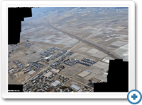
 岩手県宮古市
Miyako, Iwate Prefecture
初回掲載:2011年4月11日 18:23
-
 宮城県気仙沼市
Kesennuma, Miyagi Prefecture
初回掲載:2015年3月11日 18:00 -
 宮城県気仙沼市
Kesennuma, Miyagi Prefecture
初回掲載:2015年3月11日 18:00 -
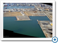 宮城県石巻市
Ishinomaki, Miyagi Prefecture
初回掲載:2015年3月11日 18:00

-
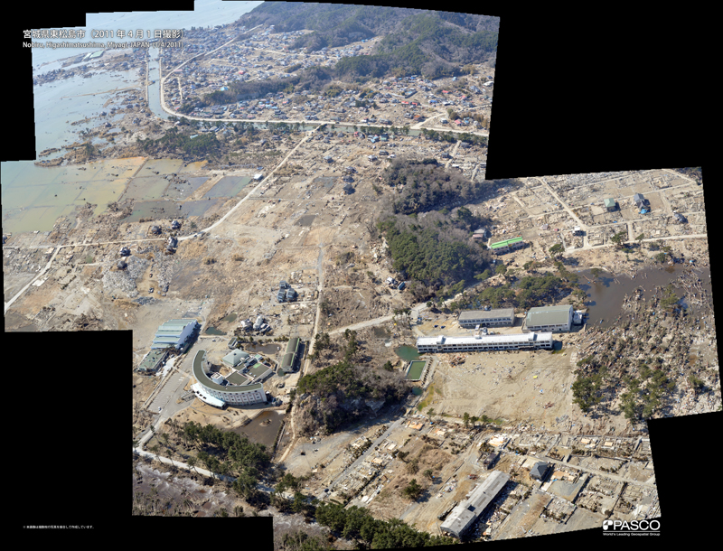
 宮城県東松島市
Higashimatsushima, Miyagi Prefecture
初回掲載:2015年3月11日 18:00 -
 宮城県東松島市
Higashimatsushima, Miyagi Prefecture
初回掲載:2015年3月11日 18:00 -
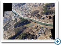 宮城県東松島市
Higashimatsushima, Miyagi Prefecture
初回掲載:2015年3月11日 18:00


-
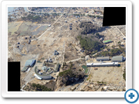 宮城県東松島市
Higashimatsushima, Miyagi Prefecture
初回掲載:2015年3月11日 18:00 -
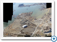 宮城県東松島市
Higashimatsushima, Miyagi Prefecture
初回掲載:2015年3月11日 18:00 -
 宮城県東松島市
Higashimatsushima, Miyagi Prefecture
初回掲載:2015年3月11日 18:00

21.合成開口レーダー衛星(TerraSAR-X)から抽出した推定湛水範囲の変化 4
3月13日、24日、4月4日に撮影した合成開口レーダー衛星(TerraSAR-X)の撮影成果から、津波による推定湛水域(水が残る範囲)の自動抽出を試みました。
これは平滑な面はマイクロ波の反射強度が弱い(暗く写る)という衛星特性を用いたものです。 ピンクの範囲が3月13日時点、その上に24日時点の推定湛水範囲をオレンジ、4月4日時点の推定湛水範囲を赤でで重ねて表示しています。
なお、平滑面を自動抽出しているため、水面に浮遊する瓦礫や復旧作業による 滑走路・道路などの整地により、自動抽出される領域に誤差が生じます。
Estimated change of the flooded range extracted from Synthetic Aperture Radar satellite (TerraSAR-X) updated by PASCO #4
PASCO attempted the automatic extraction of flooded area caused by the tsunami using the information from the synthetic aperture radar satellite (TerraSAR-X) acquired on 13 , 24 March 2011 and 4 April 2011.
This automatic extraction method utilizes the characteristics of weak microwave reflectivity from the smooth surface (dark displayed).
The pink area shows estimated flooded area of March 13, the orange area indicates the estimated flooded area of March 24 and the red area indicates the estimated flooded area of April 4.
20.合成開口レーダー衛星(TerraSAR-X)から抽出した推定湛水範囲の変化 3
2011年3月13日、24日に撮影した合成開口レーダー衛星(TerraSAR-X)の情報から、今回の津波による湛水域の自動抽出を試みました。これは平滑な水面はマイクロ波の反射強度が弱い(暗く写る)という特性を用いたものです。
桃色の範囲が、3月13日時点、橙色の範囲が同24日時点推定湛水範囲を示しています。
Estimated change of the flooded range extracted from Synthetic Aperture Radar satellite (TerraSAR-X) updated by PASCO #3
PASCO attempted the automatic extraction of flooded area caused by the tsunami using the information from the synthetic aperture radar satellite (TerraSAR-X) acquired on 13 and 24 March 2011. This automatic extraction method utilizes the characteristics of weak microwave reflectivity from the smooth surface (dark displayed).
The pink area shows estimated flooded area of March 13, and the orange area indicates the estimated flooded area of March 24.
最終更新:2011年3月26日 15:45
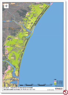
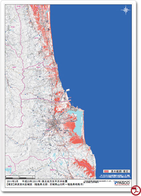
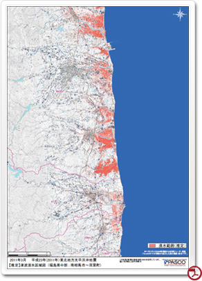
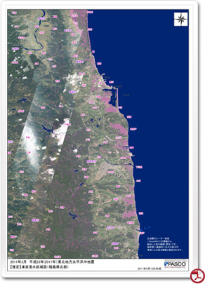
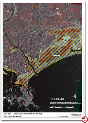
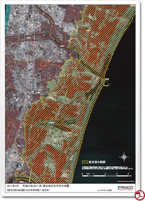
19.推定浸水範囲図(青森県~茨城県)
浸水区域判読地図は震災前後の人工衛星画像をもとに、津波による浸水範囲を判読し地図上に表示致しました。
災害復旧、復興の検討にご活用下さい。
※ 現地での確認は実施しておりません。実際と異なる事があります。
The estimated flooded area map (Aomori Pref. - Ibaraki Pref.)
The flooded areas were visually interpreted from before and after the earthquake satellite images, and overplayed on topographic maps.
We hope those maps would be useful for planning the reconstruction of damaged areas and recovery from the disaster.
*The interpreted area might be difference form the actual flooded area, since we have not conducted the field survey.
-

 青森県 - 岩手県
初回掲載:2011年3月18日 21:24
最終更新:2011年3月23日 10:33 -
 岩手県
岩手県
初回掲載:2011年3月18日 21:24
最終更新:2011年3月23日 10:33 -
 宮城県
宮城県
初回掲載:2011年3月18日 21:24
最終更新:2011年3月23日 10:33
-
 岩手県 - 宮城県
初回掲載:2011年3月18日 21:24
最終更新:2011年3月23日 10:33 -
 宮城県 - 福島県
初回掲載:2011年3月18日 21:24
最終更新:2011年3月23日 10:33 -
 福島県 - 茨城県
初回掲載:2011年3月18日 21:24
最終更新:2011年3月23日 10:33
-
 青森県(詳細)
初回掲載:2011年3月18日 21:24
最終更新:2011年3月23日 10:33 -
 岩手県(詳細)
初回掲載:2011年3月18日 21:24
最終更新:2011年3月23日 10:33 -
 宮城県(詳細)
初回掲載:2011年3月18日 21:24
最終更新:2011年3月23日 10:33
-
 福島県(詳細)
初回掲載:2011年3月18日 21:24
最終更新:2011年3月23日 10:33 -
 茨城県(詳細)
初回掲載:2011年3月18日 21:24
最終更新:2011年3月23日 10:33
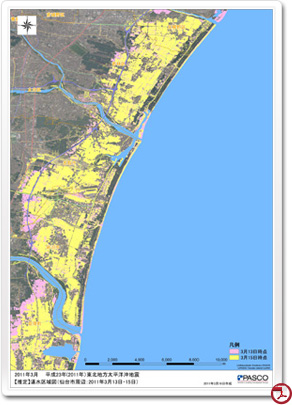
18.合成開口レーダー衛星(TerraSAR-X)から抽出した推定湛水範囲の変化 2
2011年3月13日、15日、16日に撮影した合成開口レーダー衛星(TerraSAR-X)の情報から、今回の津波による湛水域の自動抽出を試みました。これは平滑な水面はマイクロ波の反射強度が弱い(暗く写る)という特性を用いたものです。
桃色の範囲が、3月13日時点、黄色の範囲が同15日時点、黄緑色の範囲が同16日時点推定湛水範囲を示しています。
3時期の比較から、湛水範囲は縮小傾向にあるものの依然として広範囲で継続していることがうかがえます。
Estimated change of the flooded range extracted from Synthetic Aperture Radar satellite (TerraSAR-X) updated by PASCO #2
PASCO attempted the automatic extraction of flooded area caused by the tsunami using the information from the synthetic aperture radar satellite (TerraSAR-X) acquired on 13 , 15, and 16 March 2011. This automatic extraction method utilizes the characteristics of weak microwave reflectivity from the smooth surface (dark displayed).
The pink area shows estimated flooded area of March 13, the yellow area indicates the estimated flooded area of March 15, and the pea green area indicates the estimated flooded area of March 16.
Comparison of temporal acquisitions shows the shrinking trend of the flooded area, but still it is continuing in the wide range.
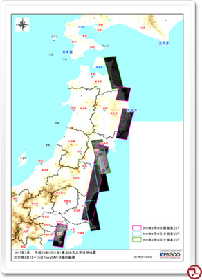
17.合成開口レーダー衛星(TerraSAR-X)から抽出した推定湛水範囲の変化
2011年3月13日及び15日に撮影した合成開口レーダー衛星(TerraSAR-X)の情報から、今回の津波による湛水域の自動抽出を試みました。
これは平滑な水面はマイクロ波の反射強度が弱い(暗く写る)という特性を用いたものです。
桃色の範囲が、3月13日時点の推定堪水範囲、黄色の範囲が3月15日時点の推定湛水範囲を示しています。
2時期の比較から、湛水範囲は縮小傾向にあるものの依然として広範囲で継続していることがうかがえます。
Estimated change of the flooded range extracted from Synthetic Aperture Radar satellite (TerraSAR-X)
PASCO attempted the automatic extraction of flooded area caused by the tsunami using the information from the synthetic aperture radar satellite (TerraSAR-X) acquired on 13 and 15 March 2011. This automatic extraction method utilizes the characteristics of weak microwave reflectivity from the smooth surface (dark displayed).
The pink area shows estimated flooded area of March 13, and the yellow area indicates the estimated flooded area of March 15. Comparison of temporal acquisitions shows the shrinking trend of the flooded area, but still it is continuing in the wide range.
16.3月14日(月)の光学衛星(EROS-B)画像
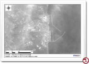
初回掲載:2011年3月16日 14:17
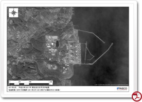
2011年3月14日(月)13時37分に撮影した福島第一原発および福島第二原発の光学衛星(EROS-B)の画像
March 14 (Mon) optical satellite (EROS-B) Image
On March 14, 2011 (Monday) the optical satellite acquired images (EROS-B) of the first and second Fukushima Nuclear Power Plant at 13:37.
15.震災後の衛星撮影範囲(合成開口レーダー:SAR)
3月15日夕方、合成開口レーダー衛星
(16日 14:17更新)
The area captured by the satellite (Synthetic Aperture Radar: SAR) after the earthquake
Evening, March 15, Synthetic Aperture Radar Satellites (TerraSAR-X) acquired the data.
The acquisition range is shown.
(Updated at 14:17 on March 16th)
最終更新:2011年3月16日 14:17
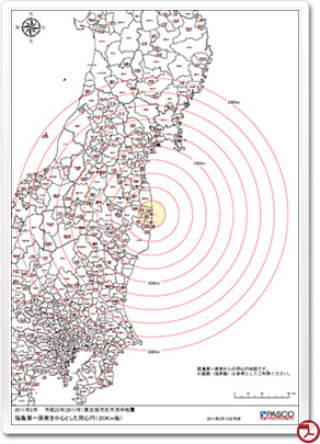
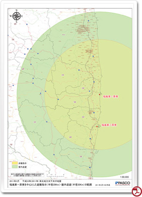
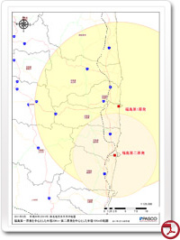
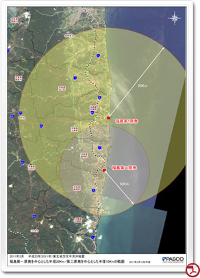
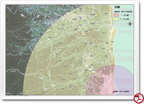
14.福島第一原発を中心とした同心円
福島第一原発を中心に20km単位の同心円を作成しました。
※範囲(境界)は参考としてご利用ください。
Concentric circles around the 1st Fukushima Nuclear Power Plant
The concentric circles of 20km around 1st Fukushima Nuclear Power Plant was created.
※ Please use the range (border) as reference.
13.合成開口レーダー衛星(TerraSAR-X)から抽出した想定浸水範囲(福島県北部) 2
2011年3月13日に撮影した合成開口レーダー衛星(TerraSAR-X)の情報から福島県北部における浸水範囲図(想定)を更新しました。
The estimated flooded area was extracted utilizing Synthetic Aperture Radar satellites (TerraSAR-X) (northern Fukushima) #2
The estimated flooded area map extracted from Synthetic Aperture Radar satellite (TerraSAR-X) acquired on 13 March 2011 in northern Fukushima prefecture has been updated.
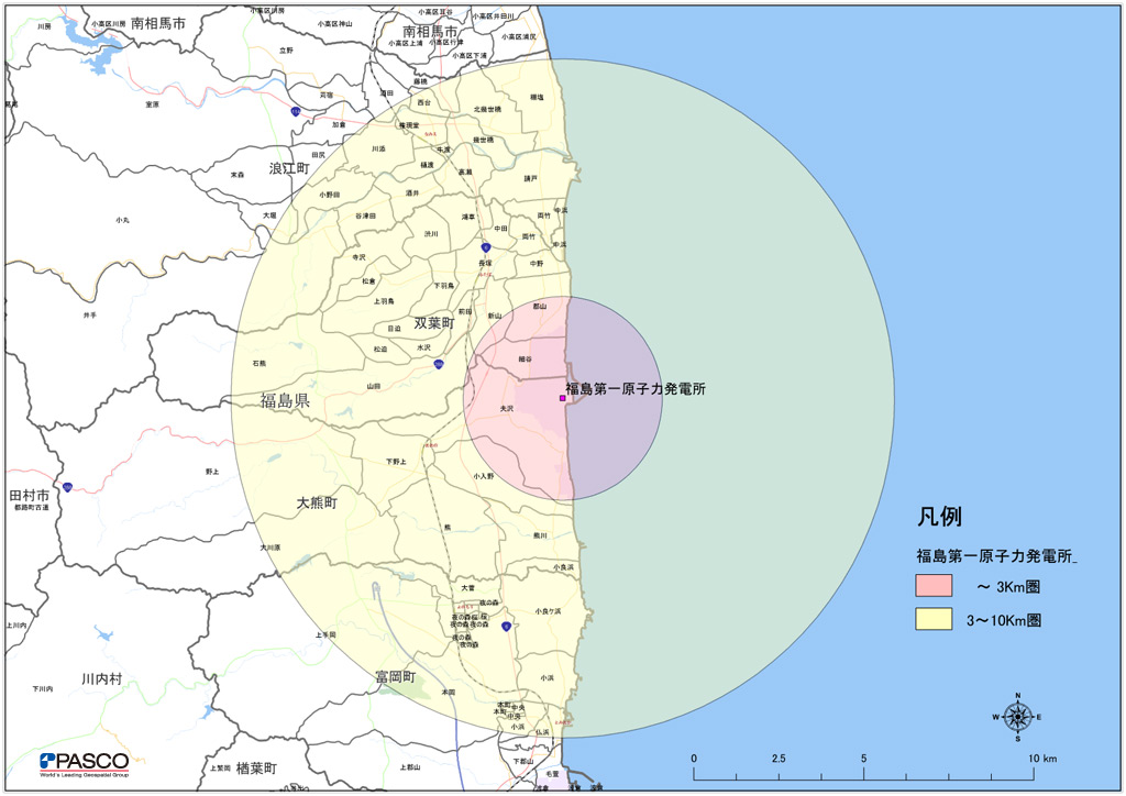
12.原子力災害対策特別措置法に基づく政府避難指示について 5
3月15日11:30頃、政府は安全上の観点から出していた福島第一原子力発電所に関する避難指示・屋内退避の範囲を拡大しました。
(15日 14:37更新)
Evacuation instructions based on the Act on Special Measures Concerning Nuclear Emergency Preparedness updated by PASCO #5
Around 11:30 on March 15, the government expanded the area to be evacuated or stayed indoor against the 1st Fukushima Nuclear Power Plant for the safety of residents.
(updated at 14:37 on 15 March)
最終更新:2011年3月15日 14:37
11.合成開口レーダー衛星(TerraSAR-X)から判読した海上の浮遊物について
2011年3月13日に撮影した合成開口レーダー衛星(TerraSAR-X)の情報から、海上の浮遊物を確認しました。
データは13日午前の情報です。現状は潮の流れ等で刻々と変化しますので、参考情報としてご利用ください。
Interpretation of the suspended and floating objects on the sea by Synthetic Aperture Radar satellites (TerraSAR-X) images.
The suspended and floating objects on the sea identified from the information acquired by the TerraSAR-X on 13 March 2011.
The data shows the information as of 13th March Morning. Since the situation is changing due to tidal flow, etc., please use as reference information only.
10.合成開口レーダー衛星(TerraSAR-X)から抽出した想定浸水範囲(福島県北部)
2011年3月13日に撮影した合成開口レーダー衛星(TerraSAR-X)の情報から福島県北部における浸水範囲図(想定)を作成しました。
(14日 16:20更新)
Extracted estimated flood area (northern Fukushima) from the Synthetic Aperture Radar Satellite (TerraSAR-X)
The estimated flooded area map extracted and created from the information of northern Fukushima prefecture acquired by TerraSAR-X on March 13, 2011.
(updated at 16:00 on 14 March)
最終更新:2011年3月14日 16:20
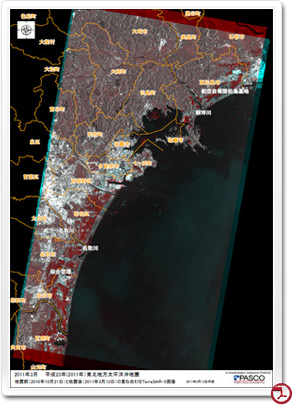
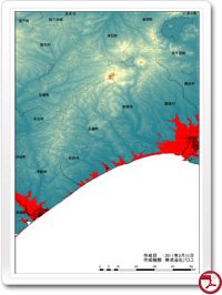
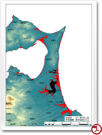
9.東日本大震災(発生前、発生後)の地形変化図 2
パスコでは2010年10月21日(発生前)と2011年3月13日(発生後)に撮影したTerraSAR-Xの画像を重ね合わせて、仙台市周辺の津波による地形変化図を作成しました。この図はTerraSAR-Xの画像の特性を活かし、地表面の凸凹が変化した箇所を抽出しています。図中の黄色い範囲が浸水区域(推定)と考えられます。
(15日 19:44更新)
Topographic change map #2 (pre and post earthquake) The Great East Japan Earthquake
PASCO created the topographic change map after Tsunami around the Sendai city utilizing superimposed TerraSAR-X images acquired on October 21, 2010 (before the occurrence) and March 13, 2011 (after occurrence). This map indicates the change of the uneven ground surface utilizing the characteristic of TerraSAR-X images. The yellow area of the map is estimated flooded areas.
(updated at 19:44 on 15 March)
最終更新:2011年3月15日 19:44
最終更新:2011年3月15日 19:44
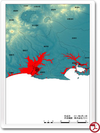
8.東日本大震災(発生前、発生後)の地形変化図
パスコでは2010年10月21日(発生前)と2011年3月13日(発生後)に撮影したTerraSAR-Xの画像を重ね合わせて、仙台市周辺の津波による地形変化図を作成しました。この図はTerraSAR-Xの画像の特性を活かし、地表面の凸凹が変化した箇所を抽出しています。濃い赤または濃い青で表示されている部分が津波で変化した箇所(浸水区域)と考えられます。
Topographic change map (pre and post earthquake) The Great East Japan Earthquake
PASCO created the topographic change map after Tsunami around the Sendai city utilizing superimposed TerraSAR-X images acquired on October 21, 2010 (before the occurrence) and March 13, 2011 (after occurrence) and this map indicates the change of the uneven ground surface utilizing the characteristic of TerraSAR-X images. The red and blue area of the map is estimated changed area (flooded).
最終掲載:2011年3月14日 15:50
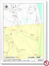
7.原子力災害対策特別措置法に基づく政府避難指示について 4
避難指示範囲の参考図を作成しました。
※本地図はあくまで参考としてご利用ください。
※実際の避難は行政機関等の指示に従うようにしてください。
(家屋形状は(株)ゼンリンのご協力で表示しています)
(14日 15:50更新)
Evacuation instructions based on the Act on Special Measures Concerning Nuclear Emergency Preparedness updated by PASCO #4
Reference maps were created for instructed evacuation range
※ Please use this map as a reference only.
※ The actual evacuation, please follow the instructions of government agencies.
The footprint of buildings is shown cooperating with ZENRIN Co., Ltd.
(updated at 15:50 on 14 March)
-
 全体図
全体図
初回掲載:2011年3月13日 18:30
最終掲載:2011年3月14日 15:50 -
 詳細
詳細
初回掲載:2011年3月13日 18:30
最終掲載:2011年3月14日 15:50
6.3月13日(日)の衛星撮影範囲(合成開口レーダー:SAR)
3月13日朝、合成開口レーダー衛星(TerraSAR-X)による撮影を実施しました。
第一報として撮影範囲をご案内いたします。
(14日 15:50更新)
Acquisition range of the satellite (Synthetic Aperture Radar: SAR) on Sunday 13 March
Synthetic Aperture Radar (TerraSAR-X) image was acquired in the morning of March 13.
Shown acquired area.
(updated at 15:50 on 14 March)
最終掲載:2011年3月14日 15:50
5.原子力災害対策特別措置法に基づく政府避難指示について 3
3月12日18:25頃、政府は安全上の観点から福島第一原子力発電所を中心とした半径20キロ、および、第二原子力発電所を中心とした半径10キロ以内の住民に対して避難を指示しました。
平成17年度の国勢調査によると、当該地域には約25,000世帯、人口約78,000人が居住していると推定されます。
本図は、上記範囲を示したものです。
Evacuation instructions based on the Act on Special Measures Concerning Nuclear Emergency Preparedness updated by PASCO #3
On March 12, the government instructed the evacuation at 18:25 to the residents within a radius of 20 km of the 1st Fukushima Nuclear Power Plant and within a 10 km radius of the 2nd Nuclear Power Plant for their safety. According to the 2005 census, it is estimated about 25,000 households and 78,000 inhabitants in the region.
This map shows the range of evacuation.
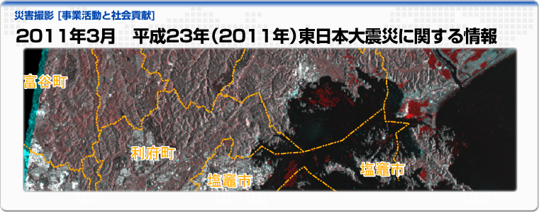
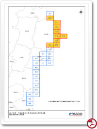
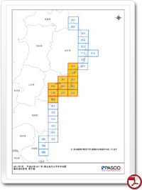
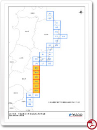
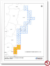
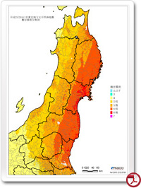
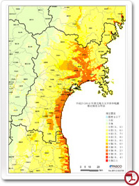
4.2011年3月 平成23年(2011)年東日本大震災 推定震度分布図
M9.0を記録した平成23(2011)年東日本大震災に関する推定震度分布図を作成しました。
※この震度分布図は計算上のもので、実際の震度を示したものではありません。
(14日 15:50更新)
Estimated seismic intensity distribution map of the Great East Japan Earthquake, March 2011.
Estimated intensity distribution map was created for the recorded M9.0 the Great East Japan Earthquake.
※This is a calculated intensity distribution map and it does not show the actual intensity.
(updated on 14 March 15:50)
-
 推定震度分布図
初回掲載:2011年3月12日 10:30
最終掲載:2011年3月14日 15:50 -
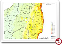
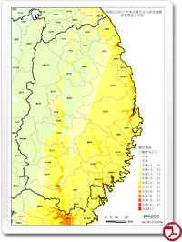 推定震度分布図(岩手県)
初回掲載:2011年3月12日 10:30
最終掲載:2011年3月14日 15:50 -
 推定震度分布図(宮城県)
初回掲載:2011年3月12日 10:30
最終掲載:2011年3月14日 15:50
-
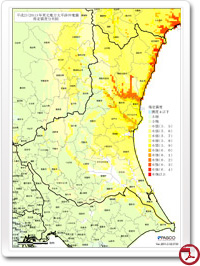
 推定震度分布図(福島県)
初回掲載:2011年3月12日 10:30
最終掲載:2011年3月14日 15:50 -
 推定震度分布図(茨城県)
初回掲載:2011年3月12日 10:30
最終掲載:2011年3月14日 15:50
3.原子力災害対策特別措置法に基づく政府避難指示について 2
平成23年3月12日06時ごろ、政府は避難指示の範囲の範囲をこれまでの3kmから10kmまでに変更しました。本図は、福島第一原発から、3キロと10キロの範囲を示したものです。
(12日 07:39更新)
Evacuation instructions based on the Act on Special Measures Concerning Nuclear Emergency Preparedness updated by PASCO #2
On March 12, 2011, at 06:00, the government instructed to expand the range to be evacuated from current 3km to 10km. This map shows the range of 3 km and 10 km from the 1st Fukushima Nuclear Power Plant.
(updated on 12 March 07:39)
最終掲載:2011年3月12日 07:39
最終掲載:2011年3月12日 07:39
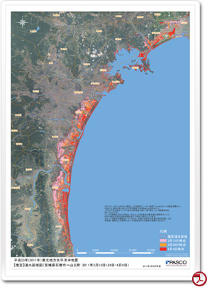
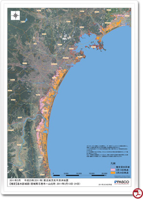
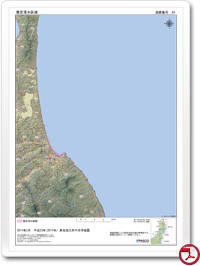
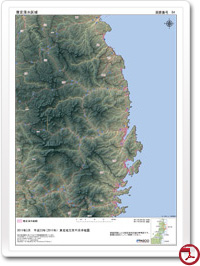
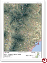
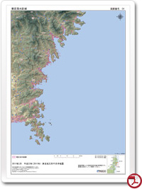
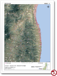
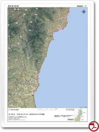
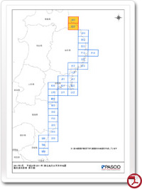
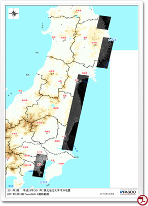
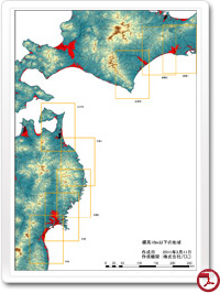
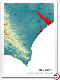
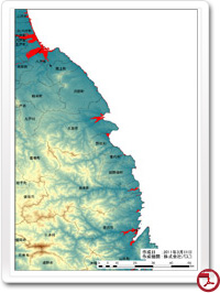
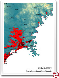
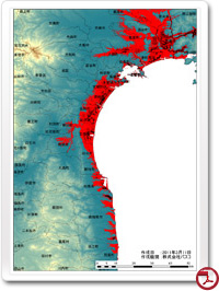
2.仙台以北の太平洋沿岸における標高10m以下の地域
平成23年3月11日14時46分頃に発生した、東日本大震災には非常に大きな津波を発生させました。津波の遡上は、地形に大きく影響されることから、標高10m以下の範囲を抽出しました。津波の被害は、非常に広範囲にわたることから、複数枚に分けて掲載しています。
(14日 15:50更新)
The area below 10m above sea level of the coastal Pacific Ocean north of Sendai
A huge tsunami occurred due to the Great East Japan Earthquake at 14:46 on March 11, 2011. Since topography was greatly affected due to tsunami inundation, PASCO extracted the area below altitude 10m. The damage caused by tsunami was very extensive. The maps are published separately as multiple sheets.
(updated at 15:50 on 14 March)
-
 作成位置図
作成位置図
初回掲載:2011年3月12日 01:05
最終掲載:2011年3月14日 15:50 -
 釧路1
釧路1
初回掲載:2011年3月12日 01:05
最終掲載:2011年3月14日 15:50 -
 釧路2
釧路2
初回掲載:2011年3月12日 01:05
最終掲載:2011年3月14日 15:50
-
 広尾
広尾
初回掲載:2011年3月12日 01:05
最終掲載:2011年3月14日 15:50 -
 三沢
三沢
初回掲載:2011年3月12日 01:05
最終掲載:2011年3月14日 15:50 -
 三陸1
三陸1
初回掲載:2011年3月12日 01:05
最終掲載:2011年3月14日 15:50
-
 三陸2
三陸2
初回掲載:2011年3月12日 01:05
最終掲載:2011年3月14日 15:50 -
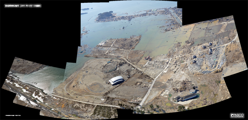
 松島
松島
初回掲載:2011年3月12日 01:05
最終掲載:2011年3月14日 15:50 -
 仙台
仙台
初回掲載:2011年3月12日 01:05
最終掲載:2011年3月14日 15:50
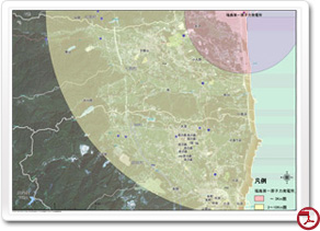
1.原子力災害対策特別措置法に基づく政府避難指示について
平成23年3月11日14時46分頃に発生した、東日本大震災により福島第一原発の2号機から放射能が漏れる可能性があるため、政府は範囲3キロ以内の住民に対して避難を指示しました。本図は、福島第一原発から、3キロと10キロの範囲を示したものです。
Evacuation instructions based on the Act on Special Measures Concerning Nuclear Emergency Preparedness
The government issued the evacuation within 3km range due to the possibility of radioactive leak from the Unit 2 of the 1st Fukushima Nuclear Power Plant as it was resulted from the Great East Japan Earthquake took place at 14:46 on March 11, 2011. This map shows the range of 3 km and 10 km from the 1st Fukushima Nuclear Power Plant.
情報掲載履歴
第1回掲載日:2011年3月11日(金) 22:30
第2回掲載日:2011年3月12日(土) 01:05 / 14日 15:50 情報更新
第3回掲載日:2011年3月12日(土) 01:53 / 07:39 情報更新
第4回掲載日:2011年3月12日(土) 10:30 / 14日 15:50 情報更新
第5回掲載日:2011年3月12日(土) 20:04
第6回掲載日:2011年3月13日(日) 13:03 / 14日 15:50 情報更新
第7回掲載日:2011年3月13日(日) 18:30 / 14日 15:50 情報更新
第8回掲載日:2011年3月13日(日) 22:10 / 24:55 情報更新 / 14日 15:50 情報更新 / 15日 19:44 情報更新
第9回掲載日:2011年3月13日(日) 23:38 / 14日 16:20 情報更新
第10回掲載日:2011年3月14日(月) 16:20
第11回掲載日:2011年3月15日(火) 12:18 / 14:37 情報更新
第12回掲載日:2011年3月15日(火) 15:30
第13回掲載日:2011年3月15日(火) 17:33
第14回掲載日:2011年3月15日(火) 18:29 / 16日 14:17 情報更新
第15回掲載日:2011年3月16日(水) 14:17
第16回掲載日:2011年3月17日(木) 11:03
第17回掲載日:2011年3月18日(金) 18:23
第18回掲載日:2011年3月18日(金) 21:24 / 23日 10:33 情報更新
第19回掲載日:2011年3月21日(月) 17:26 / 26日 15:45 情報更新
第20回掲載日:2011年4月 5日(火) 13:01
第21回掲載日:2011年4月11日(月) 18:23
第22回掲載日:2015年3月11日(水) 18:00
災害発生に伴い被災状況の把握および関係各団体への情報提供の観点から、株式会社パスコは情報の収集と公開を開始しました。
From the view point of providing information to relevant organization and grasping situation of the distressed due to the disaster outbreak, PASCO CORPORATION began collecting and publishing of information.
被災された皆様には、謹んでお見舞い申し上げます。
弊社では災害状況の的確な把握と被災地の復旧に、空間情報の処理および解析技術と防災コンサルティング技術がお役に立てるよう、より一層努力してまいります。
We extend our sympathies to everyone who was affected in this catastrophe.
In line with grasping the precise disaster condition and disaster restoration, PASCO CORPORATION is, more than ever, making efforts to provide useful services in processing of spatial information as well as technical analysis and disaster prevention consultation.
【 著作権について 】
災害緊急撮影ページ(以下、当ページ)に記載されている文書の著作権は、弊社に帰属します。
また当ページで使用しているTerraSAR-Xの著作権は、株式会社パスコに帰属します。
当ページに記載されている情報(文書及び画像)を転用・複写する場合は、下記問い合わせ先までご連絡ください。
【 Copyright 】
The copyright for the documents recorded in the disaster and emergency photos of this page belongs to PASCO CORPORATION. In addition, the copyright for the use of TerraSAR-X in this page is also the property of PASCO CORPORATION. Please contact us (see below) for permission to distribute or copy the information (documents and images) recorded in this page.
【 免責事項について 】
当ページの制作にあたっては、正確な情報の記載に努めておりますが、弊社は、当ページに記載された情報の完全性・正確性について保証するものではありません。
弊社は、当ページに含まれる情報もしくは内容を利用することで利用者に直接・間接的に生じた損害について責任を負うものではありません。
当ページに掲載されている情報が明らかに事実と異なる場合は、訂正いたしますので、お手数ですが下記の問合せ先までご連絡ください。
【 Disclaimer 】
PASCO CORPORATION strived to make the information in this page as accurate as possible at the time of publication; however PASCO CORPORATION does not guarantee integrity or accuracy of the information recorded in this page. PASCO CORPORATION accepts no liability for any loss or damage directly or indirectly, arising from the use of this information or contents. In case the information provided in this page is evidently different from the actual, in order to correct it please contact us using our contact information below.
【 お問合せ先 】
株式会社パスコ 広報部
e-mail:biz-info@pasco.co.jp
TEL:03-6412-2800