Collecting Information
PASCO Group collects and analyzes geospatial information globally. The results are used to create maps, in academic research, and in enhancing homeland security. There are many ways of collecting geospatial information, and information is gathered from all angles - through satellites, aircrafts, land vehicles, and ships.
Earth Observation Satellite
PASCO handles data from the leading commercial Earth Observation satellites launched throughout the world. Our capability for spaceborne services is to provide image data from optical and synthetic aperture radar (SAR) satellites, and to solve the customer’s needs through the regular monitoring and data analysis work.
-
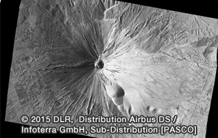
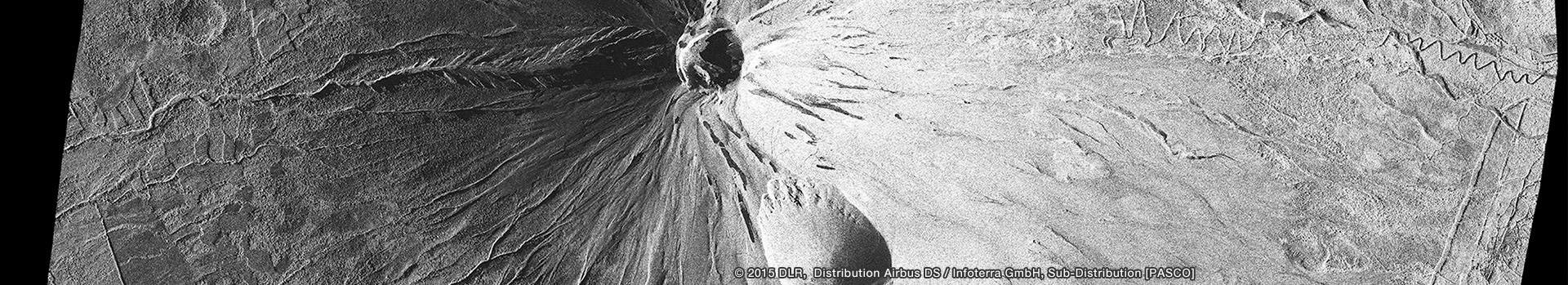
SAR Satellite
A SAR satellite acquires ground surface radar image by transmitting electromagnetic pulses and receives the echoes of the backscattered signal from the ground. SAR satellites have capability to provide day-and-night and weather-independent images.
-
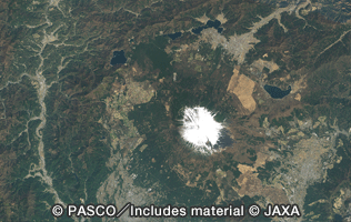
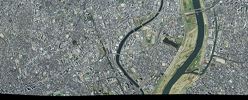
Optical Satellite
Optical satellite acquires image of the ground surface the same way as the human eye views the ground. Each optical satellite has wide range of swath (depending on the specifications of the satellite) and can perform the observations of the wide areas. And also it can generate the Digital Elevation Model (DEM) through acquisition of stereo pair or tri-stereo pair images.
-
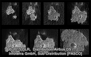
Regular Monitoring
Our satellite service has the capability to perform regular monitoring and analysis of the image data. For the monitoring, the company provides valuable information necessary for decision-making on disasters, agricultural and environmental and environmental solutions, etc.
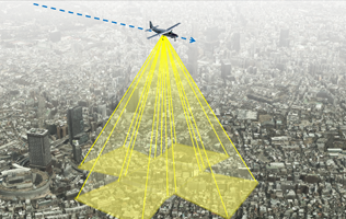
Airborne Surveying
Airborne surveying forms the core of PASCO's geospatial information business. Since our founding in 1953, we have continued to inherit and pass on aircraft surveying technologies. We constantly introduce the latest equipment, and have consistently maintained a high level technical expertise.
-
Aerial Photography Surveying
Aerial surveying technology is utilized in a wide range of fields throughout the world. These range from the creation of maps, to terrain analysis and research (rivers, soil erosion, coasts, etc.), urban planning, road planning (roads, rails, etc.), and vegetation research (forests, agriculture, lakes and marshland, etc.).
-
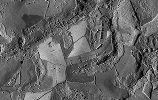
Aerial Laser Surveying
Aerial laser surveying is a technology aimed at the acquisition of 3D point group data (X, Y, and Z). It is used to create Digital Surface Models (DSM), which is one of the terrain representation methods currently available.
This data is applied to a wide range of fields, including disaster prevention, roads, erosion control, forests, agriculture, urban planning, and rivers.
-
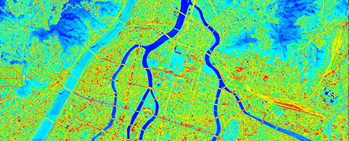
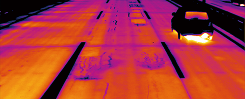
Thermal Sensor Surveying
Airborne thermal sensor surveying involves acquiring the surface temperature distribution on a wide expanse of the ground surface, in order to study, among others, the heat island effect phenomenon which is one of the contributing factors for the global warming. It is useful for research pertaining to disaster prevention and the environment, such as through gaining an understanding of surface temperature distribution of the areas near a volcano crater.
-
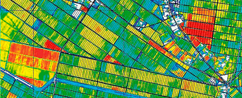
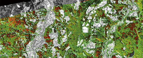
Hyperspectral Sensor Surveying
By measuring the wavelength of visible and invisible light, hyperspectral sensor surveying plays a useful role in various types of studies. These include surveys on rice growth, forest type classification map (species of trees, density of crowns, etc.), water quality surveys (chlorophyll, turbidity, etc.), and surveys on coral reefs (corals, seaweed beds, etc.)
-
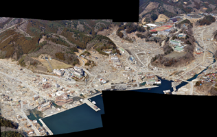
Portable Aerialphotography and Locator System (PALS)
PALS developed by PASCO is able to obtain information on the location of the subject while taking the photograph. In the event of a natural disaster, it is possible to get a grasp of the damage situation earlier using this system.
-
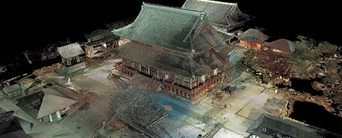
Oblique Aerial Photography Surveying
Oblique photography surveying utilizes acquisition by 5 digital cameras mounted in the aircraft and pointing towards nadir, forward, backward, right and left directions simultaneously, and capturing of wide area coverage with multiplex images by greatly enhancing the efficiency of aerial photography. With oblique airborne image, we can generate higher-density TIN model and highly accurate 3D model through aerial triangulation and image matching.
-
Airborne IFSAR Surveying
This surveying utilizes Interferometric Synthetic Aperture Radar (IFSAR) which are two antennas mounted on the aircraft for microwave transmission and receiving. The IFSAR system acquires not only the ground surface radar image but also generate the DEM based on interferometry of phase information. Additionally it provides all-weather and day-or-night capability to create terrain elevation measurements.
Vehicle/Ground Surveying
PASCO’s surveying technologies are not limited to aerial photogrammetry, but span a wide range to cover ground and indoors surveying. We provide surveying services using advanced technology. In particular, PASCO’s technology is utilized by research institutions, such as in setting up of particle accelerators for precision surveying, which calls for micro-level precision, and in the setting up of advanced medical equipment.
-
Road Condition Laser Surveying
(MMS: Mobile Mapping System)The Mobile Mapping System (MMS) is a laser-surveying device mounted on the vehicles for the measurement of 3D coordinate data and the acquisition of sequence of images of the road and its surroundings. It does these through a digital camera and 3D laser measuring device.
PASCO utilizes this vehicle measuring technology to enhance efficiency and sophistication in road maintenance and management work. In this way, PASCO provides support for optimizing lifecycle costs and extending the lifespan of social infrastructure. -
Road Condition Surveying (Real)
The Road excellent automatic logging system (Real) is a surveying system unique to PASCO. It conducts surveys on the front-view images of the road, road surface damage conditions (cracks, ruts, IRI, flatness), and coordinates (road surface coordinates, position coordinates).
-
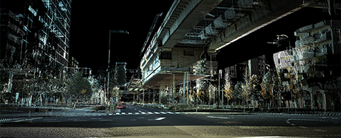
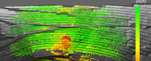
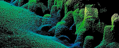
Terrestrial Laser Surveying (RIEGL)
Using a ground based 3D laser scanner that uses a pulsed laser technology, we obtain information on the shapes of our survey targets, such as structures and terrain, in the form of point group data that is a collection of 3D coordinates.
The point cloud data acquired is used not only to measure the shapes of the survey targets, but also can be processed in order to create 3D models or 2D ground plans, elevation plans, and cross-sectional diagrams. -
Ground Based InSAR and Radar
PASCO provides services through its ground based Interferometric Synthetic Aperture Radar (InSAR) and ground based radar systems, which are able to capture extremely small changes and enables the precise measurement of surface displacement in all weather conditions, in both day and night.
-
GPS Surveying
Global Positioning System (GPS) has become widely known among the general public through car navigation systems. In the surveying industry, GPS had already been gradually introduced prior to the promulgation of car navigation systems. Today, the technology is widely used in Japan as a basic surveying method that serves the objective of maintaining and managing national land.
-
TS Surveying
Total Station (TS) is a primary equipment that is commonly used in public surveying. It plays a role in all types of onsite surveying operations, from precision surveying, to reference point surveying, route surveying, plane table surveying, topographical surveying, and land surveying.
-
Precision Surveying
(Laser Tracker)PASCO's precision surveying technology is utilized in all areas that require precision surveying. These include research institutions that need a high level of precision and accuracy in their work (J-PARC, KEK, RIKEN, and research laboratories in universities, etc.), medical institutions (cancer treatment equipment facilities, etc.), high-precision plant construction, high-precision equipment inspection institutions, aerospace development agencies, etc.
Water Area Surveying
PASCO's surveying technologies extend to underwater surveying.
Topographical data for the beds of lakes and seas, which cannot be visually observed, is obtained using a shipborne narrow multibeam sonar system. In addition to providing support for the topography survey of dams and lakes, survey of the quantity of sedimentation for dams, coastal topography surveys, coastal erosion surveys, and survey of the quantity of estuary sedimentation, we also provide support for water surveys such as water quality surveys and wave observations.
-
Bathymetry Surveying
This involves the detailed shipborne measurement of shapes underwater (beds of seas and lakes, various facilities). We propose the active utilization of narrow multibeam sonar exploration system technologies as support for water administration.
-
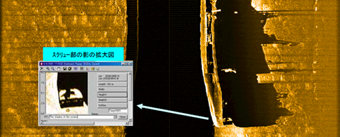
Seabed Exploration
PASCO provides clear acoustic digital images of the seabed through the latest digital side scan sonar (Sound, Navigation and Ranging) technique. We propose application and utilization of this seabed exploration technology in the form of studies of sedimentation distribution and effluent, among others.
