Providing Information
PASCO has excellent capability for visualizing the information by linking internally with variety of information and that can be identified spatially. We efficiently provide geospatial information with value added information as solutions to the client after collecting and processing the information. We believe that geospatial information will be utilized increasingly in the future, from facility management to the aggregation of information, and from drawing up regional strategies to understanding of the moving objects, etc.
System Development
Leave all the acquisition, analysis, and application work for spatial information to PASCO. We are open to consultations to discuss how we can meet the needs of all customers-from linkages with core systems to support for individual operations, and from design to development.
If you are looking for a highly reliable and secured solutions at a low cost, then why not consider PASCO's GIS Cloud?
Introducing GIS can come with cost issues, such as minimizing running costs for your server(s), only being able to purchase one license, or accumulating expenses to update maps.
We can solve these issues for you with our cloud-based GIS. All you need is Internet access and you will be able to use GIS Cloud anytime and anywhere.
-
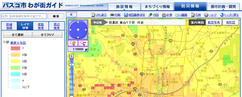
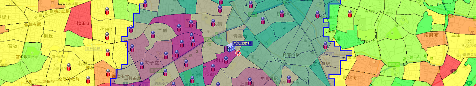
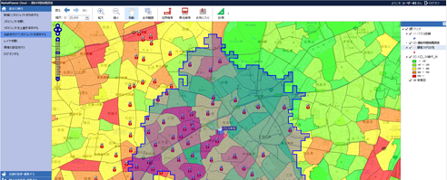
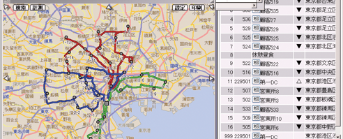
GIS Cloud services for the municipalities and central government
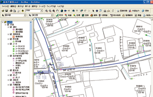
We are providing a comprehensive Geographic Information System (GIS) that allows various departments and sections within a governmental organization to securely access its shared database and individual databases using ASP service over the Local Government Wide Area Network (LGWAN) in Japan. We are also providing an ASP-format map information service for residents designed to be used on local government websites.
-
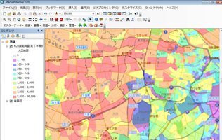
Cloud-based Regional Analysis and Marketing services for the private companies
We are providing a service to support area marketing that allows even first-time users to easily analyze its data. With this service, you can use data from the national census to reevaluate your business by examining information such as population, demographics and family structure of your neighbors, or reconsider your product lineup by referencing to the statistics on family income and expenditure.
-
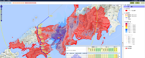
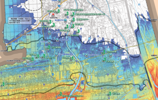
Reassurance with Disaster Prevention Systems also on the Cloud
Increasing businesses are now re-examining their disaster prevention/mitigation efforts and Business Continuity Plans (BCP). We invite you to consider our GIS Cloud as a way or method of training your staff on disaster prevention and initial response (to confirm the safety of your staff and provide instructions).
Our GIS Cloud is run on decentralized management from our secure IDC, and we are confident it will help you with your disaster prevention efforts.
-
End-to-end customization and GIS application development
If you are looking for a reliable Geographic Information System (GIS), please consider PASCO’s GIS products. PASCO has handled GIS since 1981, and has built up a wealth of experience and a track record in various types of GIS. These include area marketing and local government operational support systems that require a certain level of expertise, as well as GIS that work in tandem with core systems. We also conduct research and development into individual products such as "MarketPlanner", "LogiSTAR", "PASCO LocationService", etc. that are tailored to meet the needs of our customers.
Geospatial Information Consultancy
PASCO, as a spatial information specialist, provides various consulting services, including services for the efficient use of spatial information in local government operations and corporate activities. Consult PASCO anytime on all matters pertaining to spatial information—from acquisition methods and application methods to systematization of spatial information, as well as the combination of maps (location and position) with a variety of information sources.
-
Regional strategy analysis consultant
The way to utilize spatial information in corporate strategy. We provide support to create materials that are useful to formulate corporate strategies, by linking spatial information with various types of corporate information such as statistical information, membership information or sales information held by a company.
-
Disaster prevention and mitigation consultant
Disaster prevention and mitigation are closely related to geospatial information. PASCO, as a geospatial information provider company, provides support for the disaster prevention and mitigation plans of all parties, from the formulation of hazard maps for the disaster prevention plans of local governments, to Business Continuity Plans (BCP) for corporations, and shop risk records.
-
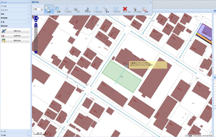
Local government and administrative consultant
Geospatial information is indispensable to local government operations. PASCO provides support for the effective use of spatial information in all local government and administrative operations. These include the construction of a comprehensive GIS, various forms of planning, planning and management of roads, bridges, and lifelines, water consulting for dams, ports, and rivers, erosion control, cadastral, land titling, forest management, and disaster prevention and mitigation consulting services.
Infrastructure Maintenance and Management
PASCO performs operational support based on capability of measuring and geospatial information consultation for maintenance and management of the infrastructures which are the foundation of residents living.
-
Water supply and Sewage Facility Management
The sewerage services are one of the local government operations that support the foundation of residents' lives.
PASCO with its skills in surveying and construction consulting, provides support for work ranging from the design of sewerage systems, to maintenance and manage operations such as management of the sewerage management inventory and investigations and countermeasures pertaining to unaccounted for water. -
Road and Bridge Design and Maintenance Support
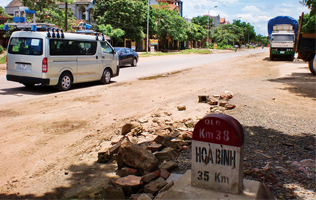
The roads and bridges that support our everyday lives are forms (representatives) of social infrastructure that have been maintained and improved on over generations, and we could say that they are important assets that we leave behind for future generations. Through the technologies that we have built up in the various fields of surveying which is included road condition survey (utilizing of Real), research, design, and systems over long years of experience, PASCO is committed to assist in the development and maintenance of social infrastructure for the new era.
-
Dam and Port Management
Japan's national territory is surrounded by the sea, and it is one of the countries in the world that boasts rich sources of water. There are many water-related facilities, such as port operations, electricity-related facilities, and water treatment facilities; there are also a wide variety of maintenance and management operations that exist in order to provide support for these facilities. Amongst these dam and port management operations, PASCO provides operational support in areas that make use of acquisition and processing technologies for spatial information.
